Sunday, June 10, 2012

Middle Settlement Lake Loop

Middle Settlement Lake loop
The afternoon of June 2, the whole family took off to Old Forge for this 10 mile loop.  We got a late start and didn't get to hiking until around 4pm.  This loop is actually a mixture of several different trails.  The terrain was really mixed.  After signing in at the trailhead registry, we made a steep ascent of about 100 feet.  Riley was wonderning what she had gotten herself into.  After that climb, things leveled off with a few ups and downs.  It had rained buckets the day before, and lots of the trail was wet, requiring some clever bushwacking to get around those sections.

Ryan loves stopping for pictures.

I've learned that when Riley gets tired, all I need to do is power her up with some snacks.  She'll eat about 10 M&Ms (biting them in half to savor the flavor) and be charged up for an hour of hiking. 

The forest was beautiful.  The bugs were low (they almost always are when you're moving).


We made our way and finally got to the lake.  It took us about 3 1/2 hours to go ~5miles.  This is Riley speed - which is just fine.  I learned from the trip the week before that I need to take more breaks.  I talked to a guy at EMS yesterday who said he did the Cranberry Lake 50 in 3 full days, but that if he does it again, he'd use 4 full days.  Ryan and I were on pace to do it in 2 days and I have the scars to prove it.  I think that a good rule of thumb is 10 minutes of break-time for every 50 minutes of 3-4 mph hiking. 

I'm fascinated by the mushrooms!  They are awesome. 

We also saw a lot of frogs and it turns out that the orange salamanders we always see on these trips are actually red spotted newts. Who knew?  I was cruising ahead of the group at one point and found a turkey with his tail spread, standing right on the trail.  Unfortunately, he left before I could get a shot or the others could catch up to see him. 

The lake was inhabited.  Inhabited by two groups of partying young men.  We met one of the groups, which consisted of a couple of soldiers from Ft. Drum.  The other group, we only heard.  The two we met were nice enough, but clearly had been drinking most of the day.  They went and joined the other group at night (we met them as they were walking to the other group), and partied until early morning.  They were chopping wood at about 2am, which is too bad as they were camped only a couple of hundred yards from us.  Incidentally, we didn't get back on the trail until almost 9am.  They were still sleeping.

Middle Settlement Lake

Ryan and I brought our fly rods.  We've been out of fly fishing for several years and decided it's time to get back into it.  Things were a little unorganized in terms of gear, but that will be solved by the next trip (USPS willing).  There were no fish to be caught on this trip.  The other two groups had been trying all weekend with no success, either.  It probably coincided with the lack of bugs (and the rising barometric pressure). 

We headed out, the following day.  There is a lean-to nearby (that the group we didn't meet used).  Those boys left right before we did.  They went back the way we came (clockwise around the lake).  Sadly, when we got to the lean-to, we found a lot of trash. 


Apparently, the trip from Middle Settlement Lake around the counter-clockwise side of the lake is not used quite as much.   The trail was iffy in several spots.  There was one serious ascent that had Riley crying.  We had to tell her that crying made it harder to breathe.  In true Riley fashion - once armed with that information, she rationalized not to cry during the tricky parts. 

The first afternoon, we came to a stream that was about 30 feet wide.  It was moving pretty well.  There was a couple of logs laid across it, but they were pretty high up.  We opted to forge the stream - using our trekking poles against the current, and all was well.  The water was knee high on me, waist high on Riley.

On the way back to the trailhead the next day, we came upon two rivers/beaver ponds that we had to cross.  The first thought was to cross the dam, but that's not always safe.  The other was to cross above the dam, but it's hard to say how deep that is.  The third way to go was below the dam.  This was our route for both crossings. 


We were pretty deep on these.  I got to almost waist height.  I had to pick Riley up and carry her over one spot.  Everyone did really well. I think next time, we'll dry it above the dam.  There should be fewer logs on the bottom and if it doesn't work, we'll back up and go with the proven method.

Dang beavers

We covered some area with ferns that were taller than me.  It was great.  It's kind of strange to think that dinosaurs walked among the same plants.  The bugs got a little worse, but still not bad.  Candie and Riley were almost bite free.  Ryan and I shed some clothing.  We didn't feel any of the bites that day, but 2 days later our arms and legs were really itchy.  Lesson learned.


We got off the trail, after traversing that steep spot we encountered in the beginning.  It was definitely trickier on the way down.  It was a great trip, despite some loud neighbors and getting wet with a little rain toward the end.  I can't wait for the next trip.  Is there a way to get paid for this?


Thanks for reading!

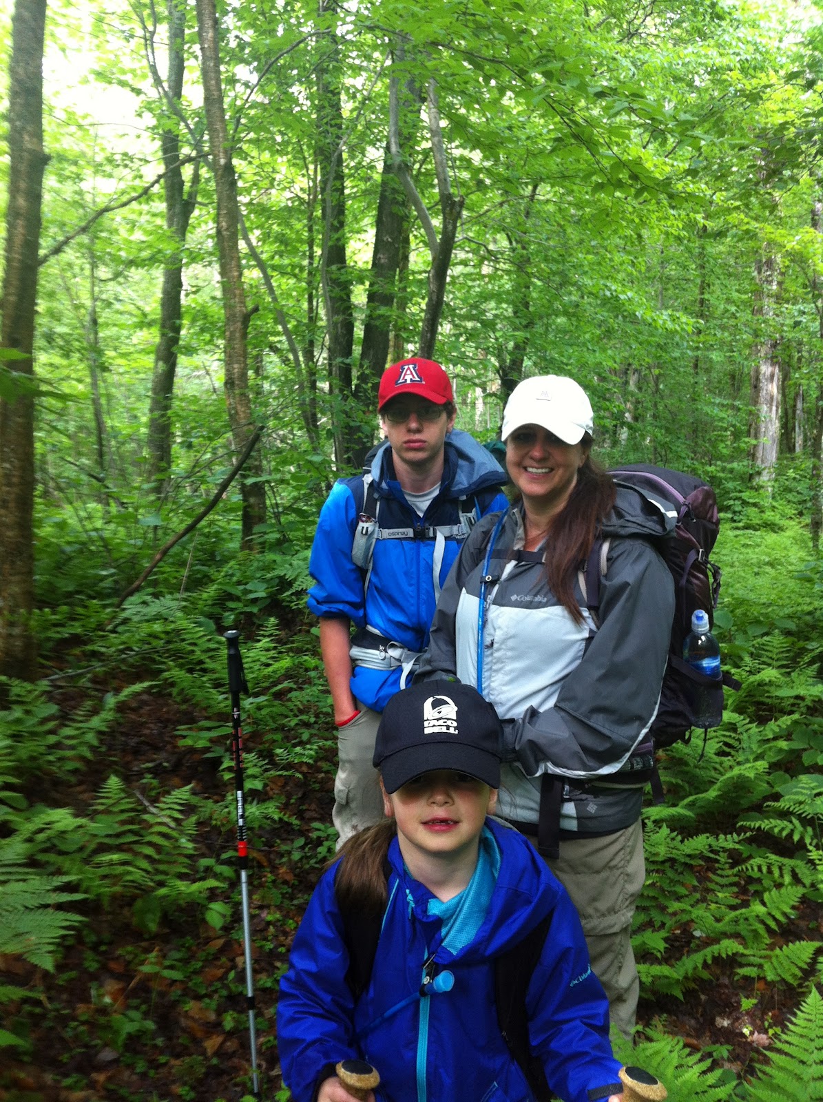
I think I was looking at a bug
on my arm.


Monday, May 28, 2012

High Falls Loop

Our route

Ryan and I just completed the High Falls Loop, with a side trip to Big Shallow Pond.  We originally planned going in the afternoon, hiking a short distance to a shelter at High Rock.  We would spend the night there and then explore the Five Ponds the next day.  We were going to make our way back up to Januck's Landing shelter and spend the night there.  Finally, we were going to hike out the morning of the third day.  There are lots of "going to's" in that paragraph.  But more on that in a bit.

The first couple of miles were like this.
Ryan is a great hiking companion.  He's only 14, but he seems to really enjoy nature and has never been afraid of hard work.  We missed the girls in the family, but were certain Riley wouldn't have had a good time.  The trail did not continue to be a "walk in the park".  We were warned about the beaver activity in the area.  It was no understatement.  In fact, if you look at a lot of maps of the trail, they'll list the loop as about 15 miles.  I found someone online who had tracked the loop with a GPS.  She listed it as 17.72 miles.  I think the trail is getting longer because of all of the re-routes the beaver ponds are creating.

This is the trail.
We saw a lot of these.  They cover acres of land.

Trekking poles are not a luxury item.
View from the campsite
at High Rock


On with our story...   So we reached our first planned site in an hour.  It was only a little more than 4 miles into the trip, but we were cruising.  It was .2 miles off the trail.  The site was beautiful.  High Rock doesn't have a shelter, but the camp site was fantastic.  There was a great breeze coming off the Oswegatchie River.  As I said before, we were "going to" spend the night here, but it was way too early for stopping.  We took a short break and walked down to the river. 
Oswegatchie River


We made our way to our big break with the loop.  We turned south and decided to check out the shelter at Big Shallow Pond.  There was no exact distance to it on the map, but we figured it was around 2 miles.  There were more beaver ponds to navigate, and after crossing a nice plank bridge, we saw a campsite set up, but no people - at least not until we came back out the next day.  The side trip seemed closer to 3 miles.  The terrain was more challenging.  We were pretty tired when we came to the shelter.  We traveled about 10 1/2 miles to get there and did that in less than 4 hours. 

The shelter was amazing.

When you're a 14 year old boy, you're in love with fire.
Kermit
Okay, it's time for a little gear talk.  I mentioned the Warbonnet Blackbird hammock in a previous post, but I didn't post any pictures.  So now I will.  What you'll see is the Mamajamba tarp over the top.  There is an optional door kit for both ends.  The tarp is great because you can pitch it according to the weather.  If it's cold or raining hard, it can be pitched in a sharp "A" going all the way to the ground.  If it's calm, or only a light rain is expected, it can be pitched broadly allowing for more openness.  I have a 900 fill 20 degree down top quilt and bottom quilt.  The effect is that you're wrapped all the way around.  It can be warmer than a sleeping bag (because there is no compressed down that you're body is smashing the insulative properties out).  The under quilt is attached underneath the hammock and can be opened on either end for more or less airflow, depending on the temperature.  There is storage inside of the hammock and the whole setup is less than 3 pounds.  Fantastic!
Also, we're in love with the JetBoil Sol Titanium cook set.  It's really light (not as light - or cheap - as an alcohol stove), but over a 4 or 5 day trip, I don't think it's much different when you take fuel into account.  It packs down to the size of a can of oil (do they still sell oil in cans?).  The great thing about it, is that it's really efficient.  Water boils almost instantly.  We're into freezer bag cooking.  We have a dehydrator at home and we'll make extra food at dinner and then dehydrate it.  We'll stash it in the freezer until we're ready for a trip.  It makes the food very light, and when we're ready to eat, we just add hot water and let it rehydrate.  On this trip we had some spaghetti and some other bean and hamburger concoction that Candie made.  We had instant oatmeal for breakfast.  Some granola and Snickers for snacks.
We love this shelter and will go back.  There are carvings on the walls dating back to the early 1960's.  There is a shelter sponsor who checks on it regularly and keeps it in top shape.  I think his name is Sam (from the shelter journal).  He does a fantastic job. 
Big Shallow - a view from the shelter
We hiked out and back to the loop.  On our way, we met a father and son who were at that empty camping site we'd seen the day before.  They were fishing from the plank bridge without a lot of luck.  They had canoed up the Oswegatchie to the camp.  Ryan and I definitely made a mental note.  It looks like a fun river to canoe. 
We worked our way to the High Falls side trail.  There used to be a hotel back this way.  I believe it burned down in the 1920's or 1930's.  The area also supported the logging industry.  We ran into some long abandoned gear. 
Solid Iron
The falls were fantastic.  Ryan explored while I soaked my feet.  We got some water out of the river and ate lunch at the shelter.  We were then on our way.
High Falls - Oswegatchie River
The next 4 or 5 miles were moderately strenuous.  There were some ups and downs and a lot of rocks.  We were re-routed around several beaver ponds and went through some very dense forest.  It was buggy, but beautiful. 
The Green Tunnel
We planned to stop at Januck's Landing shelter and stay the night.  That would have left a easy 4 mile hike back to the trail head.  We got to the shelter and there was one plastic box in it.  We hiked down to the water's edge (Cranberry Lake) and there were people just arriving by boat.  It was a big group and they were all singing the Beverly Hillbillie's theme.  In my head, I was humming Dueling Banjos and thinking about the movie, Deliverance.
There was a camp site close by, and we actually started to set up camp, but then decided it wouldn't be a great place to spend the night.  The group was already loud.  We're getting into backpacking because of the remoteness of it. 
We hiked back to the trail head and called it a day.  We were both pretty tired.  We estimate that we completed about 23 miles in 26 hours.  That's with 13 hours at the shelter at Big Shallow.  Still, it was a fantastic trip.  I love spending time with Ryan like this.  He's a really interesting person and I'm very proud of him.
Although, he can be a goofball
I almost forgot.  Flora and fauna...  We saw a ridiculous number of snakes - including one that swam across a pond.  They were all garter snakes, but cool nonetheless.  We saw beaver, frogs, toads, and a bluebird.  At night we heard loons and bullfrogs.  The forest is mixed hardwoods and conifers.  I read in a shelter journal about the wonderful fungi - and this coming from a biologist.  There was no doubt about that - and some beautiful flowers.


Thanks for reading!

Wednesday, May 16, 2012

Wehle State Park

Robert G. Wehle State Park is an incredible new state park to the region that is 15 miles and 20 minutes from our house.  It's covered with marked trails, named after the prized shorthair pointers that Mr. Wehle bred.  Dancing Gypsy is my current favorite.

The trail system at Wehle.
It's really great because you can customize your hike based on the amount of time you have, the views you want and wet or dry conditions.

We only recently discovered this amazing place.  We hardly see anyone out on the trails.  But we also haven't reached the busy season.  I'm sure that will change things.  Even though we just discovered it, it seems that all of our friends have known about it for some time.  I might have to learn some interogation techniques to find out what other cool things they're keeping from us!


The trails are really easy.  There's hardly any elevation changes.  They're great for trail running and for dogs (which is probably why they were designed).  There are some cabins that can be rented.  There are grill in the main compound for making food. 

The western part of the park is primarily cliffs that drop (somewhat dramatically - there are signs to keep the kids and pets clear of the edge) to Lake Ontario.


There are a few places to get down to the water.

Candie, Ryan, Riley & Cooper

There are couple of pieces of gear that I've enjoyed getting to know out on these easy trails: The Garmin Forerunner 305 and the Mophie Outdoors Juicepack with Neotreks topo maps.

The Forerunner is a GPS device that keeps track of your speed, distance, elevation gains and losses, etc.  It's really for running or cycling, but it also works for hiking.  It's pretty cool if you want to try to keep a certain pace or you want to run for a certain distance.  Of course, all of this data can be uploaded to your computer where you can see it and compare it to previous workouts.  It comes with a heartrate monitor you can strap to your chest.  This is handy if you want to keep your pulse at a certain rate.

The Mophie Juicepack is an iPhone case and external battery pack.  Without it, my iPhone would be out of power in a little over a day and a half.  With it, my iPhone has enough power for 3 to 4 days.  It also comes with a year long subscription to the Neotreks app.  This turns your iPhone into a fully functional, topo GPS.  By fully functional, I mean you can use it with absolutely no cell phone coverage at all.  The maps are in great detail and include just about every trail you can find.  You can tell it to bring up a bunch of helpful things (trailheads, water sources, parking, lean-tos, boat launches - and about 40 more).  It's really accurate and if you are out in the woods with the Juicepack, you could easily get a week to 10 days with the GPS if you only look at it from time to time (and power down the phone in between).  In fact, if you're so inclined, check out the free maps that Neotreks offers online.  They are amazing.  If you've found yourself playing with Google Earth for any period of time, you'll be in heaven.  One bit of warning - I use an older version of Internet Explorer on my old office computer (which has Windows XP).  You can't use the maps with the old versions of Explorer.  I downloaded Google Chrome (for free), and the maps from Neotreks work just fine with that browser.

There's a bunch of wildlife at Wehle.  Deer abound (litterally - get it?).  We always see garter snakes and frogs.  Most of the time a little red fox is hanging out around the entrance as you drive into the park.  I'm not sure if he's paid to be there.


This guy posed perfectly.
 Thanks for reading through this blog.  If you've read the earlier posts, you might want to check them out again.  I've done a little editing to make them an easier read.  I've also included more detail in a few spots.


View from the cliffs.
 

Sunday, May 13, 2012

Gleasman's Falls

That was a fun drive.

We made it out to the trail head after 4 wheeling down a muddy single lane road with lots of deep ruts.  The guidebook states that finding the trail head is one of the hardest things about this hike, and I agree.  Well, almost - but we'll get to that.


The trailhead
It's a short hike - only 6 miles round trip, but we're just getting started so we wanted something easy. 

It's an in and out hike, not a loop.  The goal of the trip is to get to Gleasman's Falls. 


Ryan on a rock in the Independence River
The falls are up past Slim, there (okay, I'm just jealous).  Sorry, I didn't get any good pics of the falls themselves (or is it, itself?) 

We ran into a group coming out, when we were going in.  They were some kind of youth group.  They wrote some strange stuff in the trail register - something about death - I don't recall exactly.  Some time after we ran into the kids, we ran into their counselor (or maybe warden - haha).  He wasn't much older.  He seemed a little stressed.  On top of the trail registers the NYS DEC mentions that filling in accurate information could SAVE YOUR LIFE (their caps, not mine).  We were dutiful in giving our information and how long we expected to be there.  We wrote 1 1/2 days.  There's a check mark that you're supposed to supply by your information when you come off the trail.  When we got back the next day, it had already been checked.  Rotten kids. 

Now, there are no "official" campsites on this trail - but there is an "informal" one.  We stayed at the informal one.  I'm pretty sure that the rules state you can camp anywhere on NYS land as long as you're 150 feet from the trail.  The site we stayed at was right on the trail.  I'm not sure if we were in the wrong or in the right for staying there.  There was a fire ring and clearly some spots for tents.  There were even cut logs for stools or tables.  Either way, we are committed to practicing "Leave No Trace". LNT is something my dad taught me in the Chiracahuas, and on Mount Graham, and in the Wetstones, and at the Cochise Stronghold, and on Mount Lemon, and Patagonia, etc. (you get the idea - that was really just a little appreciation shout-out to my dad for taking me to all of those great places on the weekends when I was a kid - we'd get back to camp from a hike and he'd always have a pocketful of trash that he picked up on the trail).

We did pass an old beaver dam/pond.  Those beavers are really cute, but boy can they do some damage to an area.


A beaver chewed log.
 

Skeletons


So, what was the hardest part of the trip?  A few mosquitoes and a lot of little annoying flies.  We only had a few bites, and they didn't even itch that much, but on the way back, they were all around our heads.  When keeping a good pace, they didn't bother us. But goodness help you when you stop (resting with the short legged member of our group).

We saw some cool wildlife.  We were privately hoping for a bear (at least during the day), but didn't see anything bigger than a chipmunk.  In fact, we saw:  frogs, salamanders, toads, chipmunks and a hummingbird.  We heard all kinds of birds (the woodpeckers are cool) but really didn't see many.  The forest is mostly hardwoods: cherry, beech, maple and hemlock.  There are always some conifers. 


On the edge of the trail

Once we noticed the salamanders,
they seemed to be everywhere.


It was a great first outing. We've already planned our next trip.  We picked up some stuff that we wished we'd had:  baby wipes, pot scrubbers and Advil PM. 

For gear, today I'll write about shelters.

We use two shelters (although, I bet that in the not-so-distant future, we'll all use the same thing). 

Candie, Ryan and Riley sleep in a Sierra Designs Mojo 3.  It's an ultralight 3 person hybrid tent.  The hybrid part is because half of the tent is a single wall design (light, but tends to promote condensation from temperature differentials and vapor that escapes while breathing) and the other half (where you lay your head) is double wall.  It's a great tent that weighs 4 pounds.  That's really light when you break that weight down per person.  It did get a little wet inside, but aired out just fine.  It's a freestanding tent, so there aren't a lot of annoying guy lines coming off of it (to trip over).  I used to tubes of seam seal on it.  I'm really excited to see how well it performs in the rain.  We don't have a footprint for it (a piece of material that goes on the ground to protect the bottom), because I didn't want the extra weight.  Every gram counts when you're carrying everything up a hill.  I think I'm going to get some house wrap (Tyvek) and cut it to shape.  It's really light and really inexpensive.  It dries quickly when wet and can be stored outside the pack through a shock cord or strap.

I'm using a Warbonnet Blackbird 1.1 double layer hammock with a Mamajamba tarp.  Together the hammock and tarp weigh 2 1/2 pounds.  I'm pretty sure this is what we'll all be using eventually - when Riley gets bigger.  Using a hammock has garnered a huge following in the backpacking community.  The advantages include low environmental impact (you can hang it anywhere with trees - over rocks, over bushes, over water), lightweight and fast easy set up (about 2 minutes).  The tarp is set up over the hammock and can be put up first if it's raining, so you can keep all of your gear dry while putting everything else up.  You can even attach doors on either end of the tarp, making it fully enclosed.  There are no condensation issues.  There is no crawling on the ground.  You don't have to worry about critters getting at you.  The primary advantage, however, is comfort.  People often claim that they fall asleep and wake up in the same position because they sleep so soundly.  Also, people with backs that give them trouble love hammocks.  It seems strange, but it's true.  Also, there's no ground dampness to deal with.  There are special considerations for staying warm, and I'll get into that another time -but they can be used in temperatures below 0 degrees.

That's it for this report.  I've never written a blog before.  This is a pretty cool way of recounting a trip.  I heard recently that events happen in 3 stages: anticipation, participation and recollection.  We have a hard time remembering things because so many things in our life are at different stages.  People who wish they could remember events better are advised to do 2 things: think about an event you really want to remember while it is happening and acknowledge that you want to remember it (try to take mental snapshots of what you see, mental recordings of what you hear or what you feel - with descriptors of those feelings as the events unfold); the second is to actively recollect the event soon after it happens.  This is my recollection.


Ryan cruising ahead


Chubby cheeks


Welcome

Hello

The family and I  have been getting into hiking, and as an extension, backpacking (well, Candie, Ryan and I - Riley still needs some "encouragement").  We decided to chronicle where we go and anything noteworthy about our experiences.  We're doing this primarily to help us remember the places and what we see, but also to let any and all who care, see what we're up to.  We're pretty far from our immediate families - and we anticipate being absent from our friends in the area on a lot of weekends and occasional longer trips, so this will be our way of sharing.

Anyone who knows me, knows that when I get really interested in something, I don't just dip a toe, so to speak.  I dive right in.  One example of this behavior would be my obsession with music.  In the past 7 or 8 years I went from playing a little acoustic guitar for myself, to teaching a number of students to play the guitar (or to play it better), to acquiring an entire studio full of production and live equipment, to starting a band (Cooper's Kennel) and playing out at clubs and parties on a pretty regular basis.  We even put out some original music on iTunes, and are working on more.


Game face


Candie is very patient and encouraging with all of this, and most of our friends just smile and shake their heads.

I watched a movie about 6 months ago, called Southbounders.  It's a story about some people who hike the Appalachian Trail from Maine to Georgia (which is a little unusual - most people go the other direction, but I digress).  I was amazed that I didn't know about this trail.  Sure, I'd heard of it, but I didn't know any of the details.  I told Candie and the kids about it.  They too were unaware that there was a continuous trail that goes from Springer Mountain in Georgia, all the way to Mount Katahdin in Maine.  That's almost 2200 miles of marked trail.  Anyway, it was interesting to us.  We've always enjoyed car camping.  We even went so far as to buy some kayaks and started using those to transport our gear to different camps on different lakes.  But, for the most part, the Appalachian Trail was forgotten.

A couple of months later, I got sick.  It was pretty bad and I was out of commission for a week.  I was miserable and used streaming video through Netflix to fill my fevered waking hours.  One of the movies that caught my delirious eye was the National Geographic special on the Appalachian Trail.  I watched it.  Then I asked Candie to watch it.  Then I asked Ryan and Riley to watch it.  Then I think I might have watched it once or twice more on my own.

Since then, I've been hooked on the idea of this trip some day.  I started doing A LOT of research on all things backpacking.  I spent hours listening to podcasts about ultralight and practical backpacking while driving for work.  I read countless articles and joined a half a dozen online forums about the Appalachian Trail (the "AT"), hiking and backpacking.  I learned about gear, tying knots, first aid and renowned backpacker's stories.  I wrote to people who had completed the AT and asked them questions about their trek.  I read a half  dozen books on the subject.  I started acquiring the gear I would need based on this research.  I bought (and patiently waited for) gear from all over the country.  Big companies and cottage businesses have sent me packages - that I pounced on when I found them on my doorstep after coming home from work.  I became sort of a creepy lurker at Eastern Mountain Sports in Syracuse.  I'm a gear nerd, so I intend to post here and there about what we own and what we think about it.

It dawned on me that we have, in our own "backyard", some really amazing trails and peaks.  The Adirondacks are covered with them. It took absolutely zero convincing of Candie and Ryan to start planning trips to get out, backpack and explore.  Like I said at the beginning, Riley needs encouragement in this area, but we're convinced that as she gets used to it, she'll enjoy being out there as much as we already do. 


You should be here

So after a few months of research and ordering gear, I finally had 95% of what I needed to backpack in 3 of the 4 seasons on the AT, or in the Adirondack mountains.  I have so much theoretical knowledge, but not much that is practical.  The family and I have been going out for day hikes locally, but hadn't taken the overnight plunge.  It became unbearable - and May in Northern New York brings on some serious Spring Fever - so on a Saturday, after one of Riley's T Ball games - we drove the 50 minutes to EMS and outfitted Candie, Ryan and Riley with all of the essentials.  I won't say how much all of our newly acquired, lightweight, top of the line gear cost us, but I will say a week in Hawaii with the family would have been less.

3 months for me to outfit, 90 minutes for the rest of the family...and we were off that very afternoon onto our first overnight backpacking trip.


Our packs